
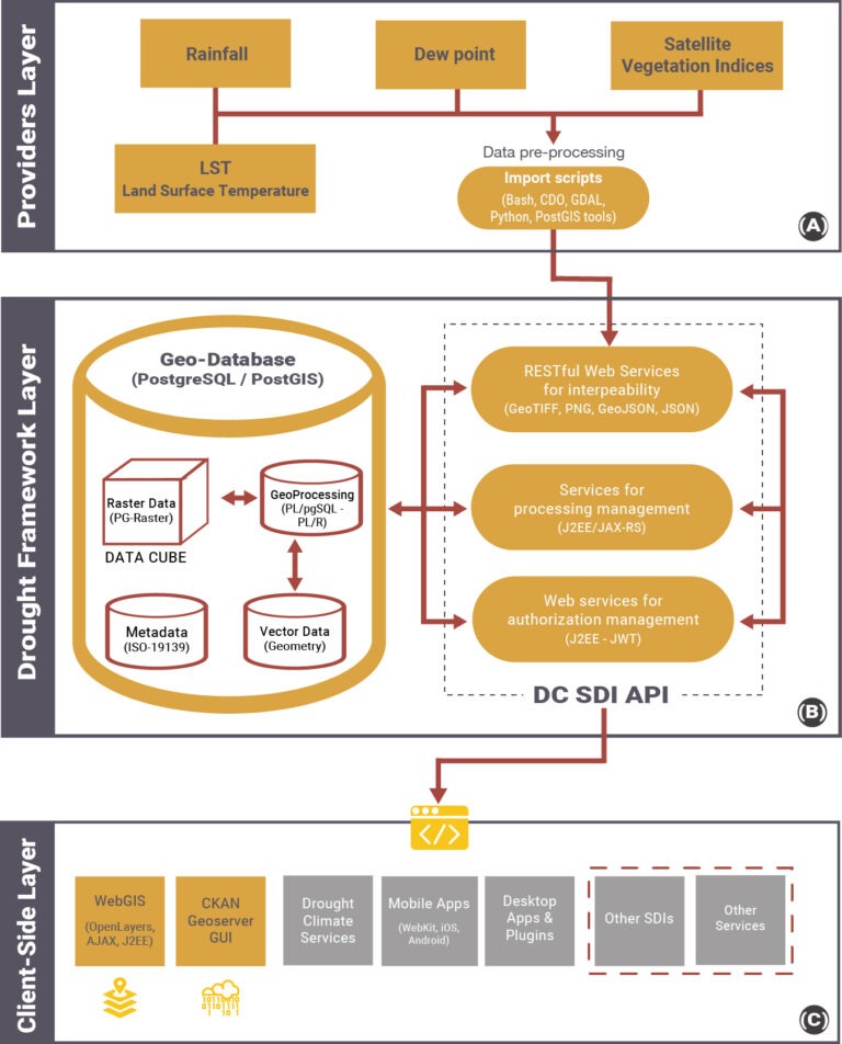
The Providers Layer is in charge of managing input data coming from different sources (MSWEP rainfall, ERA5-Land LST and Dew point and MODIS NDVI) and storing them into the Geodatabase (GeoDB), implemented into the Framework layer. The OGC data formats actually supported by the Drought Central SDI are the NetCDF for input MSWEP rainfall and ERA5-Land LST and Dew point datasets, and the Well-Known Text (WKT) for vectors used for the extraction and processing functions.
MODIS data are in Hierarchical Data Format-Earth Observing Systems (HDF-EOS) format, an approved standard recommended for use in NASA Earth Science Data Systems.
Specific Bash scripts have been developed in order to download and prepare input data before saving them into the GeoDB.
Geospatial Data Abstraction Library (GDAL) and PostGIS reprojection, tiling and storing functions are used to improve the GeoDB performances and to harmonize the datasets with the data model.
All datasets are reprojected into a common and widely used reference system: the EPSG:4326 (i.e. Latlong, WGS84). The same Bash scripts call RESTful Web Services supplied by the Framework Layer to store the datasets into the GeoDB.
A continuous input data updating is ensured by cron daemon (crontab file) that launches the scripts automatically.
The Drought Framework Layer (B) is the main component of the Drought Central SDI architecture, in which the PostgreSQL Data Cube represents the only environment for data storage and geoprocessing.
At this implementation stage, geoprocessing queries do not completely follow OGC WPS specifications, working with REST Web Services instead of SOAP. All the services allow the storage of new data while their retrieving and processing are developed locally using REST paradigm, and called through simple HTTP GET and POST operation requests. PostgreSQL Data Cube is used to store input data (rainfall, LST, Dew point, NDVI, EVI), to perform all geoprocessing procedures (queries, indices elaborations, statistical operations, etc.), and to generate intermediate data (LSTmean, LSTmin, LSTmax, VPDmean, NDVImin, NDVImax) and output images (SPI, LST anomalies, VPD anomalies, TCI, VCI, VHI) with different formats, i.e. GeoTIFF, PNG, ASCII Grid.
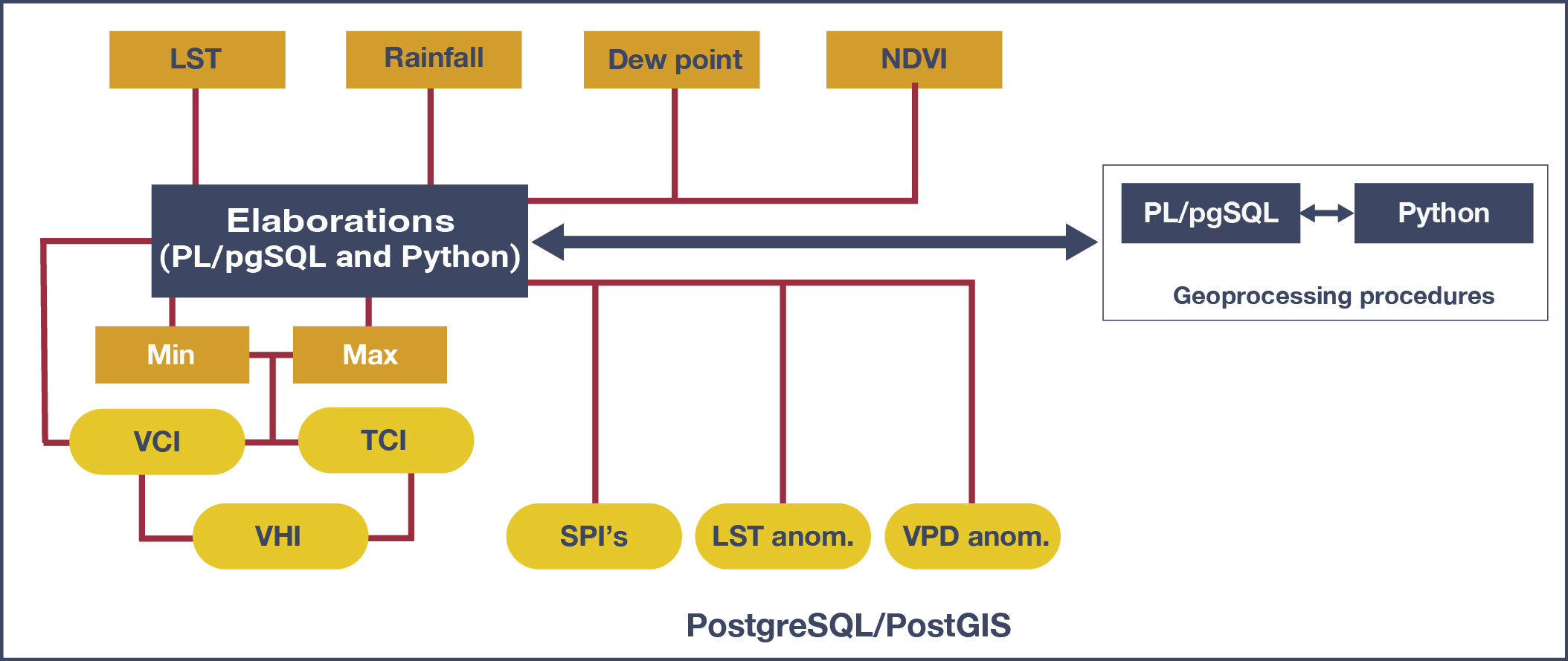
Though all the indices are calculated inside PostgreSQL, the different complexity of vegetation and rainfall indices computation has forced to use different libraries. TCI and VCI, in fact, result from simple arithmetic operations that can be done directly in PL/pgSQL using PostGIS library, successfully taking advantage of its features.
The SPI index, instead, is obtained with more complex statistical functions (fitting of a Gamma probability distribution, transformed into a standard Gaussian variable). For this reason, SPI elaboration has been implemented with the integration of a specific R library with PostGIS library. The integration between R engine and PostGIS is made possible by PL/R, the R wrapper for PostgreSQL.
A process-based SDI should stress information communication in order to reach a wide range of users and facilitate effective decision planning.
The web services implemented in the Client-side Layer (C) support the development of custom applications for the dissemination of results and services handling.
Custom client applications are developed following the specific user’s needs (researchers, practitioners, public authorities and community) taking advantage of interoperable services supplied by the Drought Framework Layer.
The RESTful API (Application Programming Interface) functions of the Drought Framework Layer allows to:
- create WebGIS applications, customized websites, and services that require Drought Central SDI data;
- develop a plug-in for other desktop GIS applications such as QGIS or ArcGIS;
- share and integrate Drought Central data with other interoperable SDIs.